Unit Preferences
| REQUIREMENTS | |
| Permission | Observation Administrator or higher |
| Connectivity | Online only |
InfoEx offers flexibility by allowing each operation a choice over unit preferences. These control the default unit during observation entry and which unit is consistently displayed in reports.
There is a single field with unit preferences for Canadian and Swedish subscribers and OGRS operations in the International system (Wind Speed Unit in Weather Observations).
There is a large choice of unit preferences between U.S. Customary Units (Imperial) and metric for SWAG operations in the International system
Your map views in InfoEx cover the entire world. You can select which map layer you wish to use at any time to view the region you are interested in. You may prefer a satellite view at some times, or a topo map view at others. Some regions may have a topo map available that has advantages over the standard InfoEx topo map view.
If a freely available map of the correct format (wms) is available for a region, it is relatively easy to add it to the InfoEx map layers. Also compatibly geo-referenced aerial photography data can potentially be added to the satellite layer (see the Panorama ski hill in the Canadian InfoEx service for an example of this).
This page describes how an Operation Administrator can specify the map layer preferences for the operation.
Step-by-step description
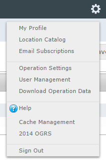
| 1. | Select 'Operation Settings' from the administration menu (cog wheel) (Fig. 1) and then the Map Layers tab in the Operation Settings page. |
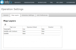
| 2. | The Operation settings page Map Layers tab for the operation (Fig. 2). This shows the Topographic map as the Operation Default map and the Satellite map will not be available. |
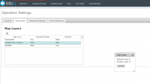
| 3. | Highlight the Map Layer row you want to select as your default or that you want to disable. Click on the pencil icon above the information table to open the Edit Layer dialogue window. Select the checkbox for either Default Layer or Disable Layer and select Update (Fig 3). A confirmation message that the setting has been updated will be displayed, and your choice will be reflected in the Map Layers information table. |
Functionality tested by
- Mar 23 2019: Stuart Smith


