Difference between revisions of "Adding locations to the location catalog"
Jump to navigation
Jump to search
(→Step-by-step description) |
(→Step-by-step description) |
||
| (41 intermediate revisions by 2 users not shown) | |||
| Line 3: | Line 3: | ||
This document describes how to add locations to the location catalog of your operation. | This document describes how to add locations to the location catalog of your operation. | ||
| − | |||
==Step-by-step description== | ==Step-by-step description== | ||
| Line 10: | Line 9: | ||
|- | |- | ||
|class="StepNum" | 1. | |class="StepNum" | 1. | ||
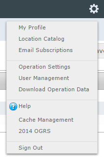
| − | |[[File:AdminMenuOperationAdministrator.png|300px|thumb|right|Fig. 1: Administration menu for operation administrator]] Select | + | |[[File:AdminMenuOperationAdministrator.png|300px|thumb|right|Fig. 1: Administration menu for operation administrator]] Select 'Location Catalog' from the administration menu (cog wheel) (Fig. 1). |
|- | |- | ||
|class="StepNum" | 2. | |class="StepNum" | 2. | ||
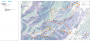
| − | |[[File:LocationCataolgScreen.png|300px|thumb|right|Fig. 2: Location catalog screen]] This will get you to the location catalog screen | + | |[[File:LocationCataolgScreen.png|300px|thumb|right|Fig. 2: Location catalog screen]] This will get you to the location catalog screen (Fig. 2). Please note that depending on your connectivity and the size of your location catalog, it might take a while to load your entire catalog and display all of the locations. A progress bar at the top of the catalog indicates when it is downloading. |
| − | + | ||
| + | The location catalog screen shows your location hierarchy tree on the left and a map on the right. | ||
|- | |- | ||
|class="StepNum" | 3. | |class="StepNum" | 3. | ||
| − | |Expand the location hierarchy tree | + | |Expand the location hierarchy tree as required by clicking on the little plus (+) signs left of locations that contain other locations. |
| − | + | The locations in the location tree are sorted by location type first and within each type, they are sorted alphabetically. The location types are sorted as follows: | |
| + | *[[Location types and symbology#ForecastArea|Forecast area]] | ||
| + | *[[Location types and symbology#OperatingZone|Operating zone]] | ||
| + | *[[Location types and symbology#PermanentClosure|Permanent closure]] | ||
| + | *[[Location types and symbology#Road|Road]] | ||
| + | *[[Location types and symbology#Rail|Rail]] | ||
| + | *[[Location types and symbology#Route|Route]] | ||
| + | *[[Location types and symbology#SkiRun|Ski run]] | ||
| + | *[[Location types and symbology#ControlRoute|Control route]] | ||
| + | *[[Location types and symbology#AvalanchePath|Avalanche path]] | ||
| + | *[[Location types and symbology#WeatherSite|Weather site]] | ||
| + | *[[Location types and symbology#ShotPlacement|Shot placement]] | ||
|- | |- | ||
|class="StepNum" | 4. | |class="StepNum" | 4. | ||
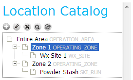
| − | |[[File: | + | |[[File:CatalogHighlightedLocation.png|300px|thumb|right|Fig. 3: Location catalog with highlighted location and administrative buttons]] Navigate to the intended parent of the new location and click on it. The parent location is now highlighted in blue (Fig. 3) and the map will automatically zoom to the location of the parent location. To add a location either click on the [[File:ButtonAdd.png]] above the top left corner of the location catalog (Fig. 3) or right click on the parent location itself and select 'New'. In both cases, a list of location types supported under the current parent location appears. Choose the appropriate type for your new location. |
| − | |||
| − | |||
|- | |- | ||
|class="StepNum" | 5. | |class="StepNum" | 5. | ||
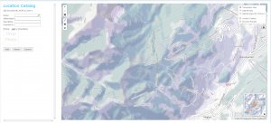
| − | |Enter the following information for the new location into the fields | + | |[[File:CatalogAddNewLocation.png|300px|thumb|right|Fig. 4: Location catalog page when adding a new avalanche path location.]] |
| − | * '''Name''' (required): Full name of the location | + | You will now be presented with a blank map and a dialog box for information about the new location on the left (Fig. 4). Enter the following information for the new location into the fields provided: |
| − | * '''Abbreviation''' (required): Abbreviation to be used for the location in the tabular InfoEx reports. | + | * '''Name''' (required):<br/>Full name of the location |
| − | * Description: Detailed description of the location | + | * '''Abbreviation''' (required):<br/>Abbreviation to be used for the location in the tabular InfoEx reports. |
| − | * External ID: The external ID of a location is required if your operation submits their observations from an external database system via the API (see [[ | + | * '''Description''' (optional):<br>Detailed description of the location |
| + | * '''External ID''' (only accessible to super users):<br/>The external ID of a location is required if your operation submits their observations from an external database system via the API (see [[Submitting observations to the InfoEx via the CAAML 3.0.3 API]] for more information). The external ID is also required for locations that already existed in the legacy CAAML driven InfoEx and have historic observation associated with them. | ||
| + | * '''Elevation''' (weather site only):<br/>Elevation of weather site in meters. When you create a new weather site, its elevation will automatically be extracted from the map. You can, however, overwrite the automatically created value. | ||
{{Note|Since locations are primarily referred to by name in the InfoEx system, it is not advisable to create multiple location of the same type with the same name. However, the system currently does not explicitly check for it.|NoteNoImage}} | {{Note|Since locations are primarily referred to by name in the InfoEx system, it is not advisable to create multiple location of the same type with the same name. However, the system currently does not explicitly check for it.|NoteNoImage}} | ||
|- | |- | ||
| Line 36: | Line 47: | ||
|Add an appropriate geometry to the location. See [[Location types and symbology]] for details on the supported geometries for the different location types. | |Add an appropriate geometry to the location. See [[Location types and symbology]] for details on the supported geometries for the different location types. | ||
| − | There are | + | There are two options for adding geometries to a location: |
| − | * Entering the geometry directly using the available drawing tools. See [[ | + | * '''Entering the geometry directly using the available drawing tools'''.<br/>See [[Creating the geometry of a new location using the available drawing tools]] for more details on this method. |
| − | * Importing the geometry from a Google Earth KML file. See [[Importing the geometry of a location from a KML file]] for more details on this method. | + | * '''Importing the geometry from a Google Earth KML file'''.<br/>See [[Importing the geometry of a location from a KML file]] for more details on this method. |
| − | |||
|- | |- | ||
|class="StepNum" | 7. | |class="StepNum" | 7. | ||
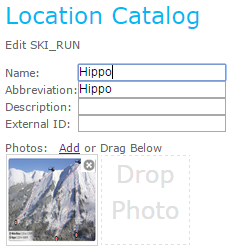
| − | | | + | |[[File:CatalogAddPhotoToLocation.png|300px|thumb|right|Fig. 5: Adding a photo to a location.]] |
| − | {{ | + | * To add a photo to a location, drag the photo onto the square below the regular information fields for the location or click on the 'Add' hyperlink above the square to open the regular file dialog box. You can add photos until you hit the maximum allowed for each location. |
| − | {{ | + | {{Note|InfoEx will only start uploading the photo to the database when you click on the final {{ButtonGrey|Add}} as described below in stage 8. The upload is then done in the background and depending on the upload internet connection speed and the size of the photo(s) could take significant time (many minutes) for each location. It is recommended to verify the photo(s) has uploaded before either closing down InfoEx or adding a photo for another location. There is potential for the upload to fail if a careful process is not followed.|NoteWithImage}} |
| + | * To change the order of the uploaded images, arrange the thumb nails into the desired order. | ||
| + | * To delete a photo, click on the [[File:ButtonDelete.png]] in the top right corner of the photo. | ||
| + | |- | ||
| + | |class="StepNum" | 8. | ||
| + | |Click on {{ButtonGrey|Add}} to add the new location to the location tree of the operation. This will add the new location to the location tree and return you to the regular location catalog screen (Fig. 2). | ||
|} | |} | ||
==Related documents== | ==Related documents== | ||
| − | + | {{PagesLocations}} | |
| − | |||
| − | |||
| − | |||
==Functionality tested by== | ==Functionality tested by== | ||
| − | * | + | * Dec. 22: Pascal Haegeli |
| − | [[Category:Super User]][[Category:Operation Administrator]][[Category:Locations | + | [[Category:Super User]][[Category:Operation Administrator]][[Category:Locations]][[Category:Version 3.4.0]] |
Latest revision as of 15:21, 3 April 2019
| REQUIREMENTS | |
| Permission | Operation Administrator or higher |
| Connectivity | Online only |
This document describes how to add locations to the location catalog of your operation.
Step-by-step description
| 1. | Select 'Location Catalog' from the administration menu (cog wheel) (Fig. 1). | ||
| 2. | This will get you to the location catalog screen (Fig. 2). Please note that depending on your connectivity and the size of your location catalog, it might take a while to load your entire catalog and display all of the locations. A progress bar at the top of the catalog indicates when it is downloading.
The location catalog screen shows your location hierarchy tree on the left and a map on the right. | ||
| 3. | Expand the location hierarchy tree as required by clicking on the little plus (+) signs left of locations that contain other locations.
The locations in the location tree are sorted by location type first and within each type, they are sorted alphabetically. The location types are sorted as follows: | ||
| 4. | Navigate to the intended parent of the new location and click on it. The parent location is now highlighted in blue (Fig. 3) and the map will automatically zoom to the location of the parent location. To add a location either click on the | ||
| 5. |
You will now be presented with a blank map and a dialog box for information about the new location on the left (Fig. 4). Enter the following information for the new location into the fields provided:
| ||
| 6. | Add an appropriate geometry to the location. See Location types and symbology for details on the supported geometries for the different location types.
There are two options for adding geometries to a location:
| ||
| 7. |
| ||
| 8. | Click on Add to add the new location to the location tree of the operation. This will add the new location to the location tree and return you to the regular location catalog screen (Fig. 2). |
Related documents
- Location catalog overview
- Location types and symbology
- Location hierarchy
- Adding locations to the location catalog
- Editing locations in the location catalog
- Deleting locations from the location catalog
- Changing the hierarchy among your locations
- Searching for a location in the location catalog
- Viewing photos
- Downloading your location catalog as a KML file
Functionality tested by
- Dec. 22: Pascal Haegeli
