Difference between revisions of "Viewing photo overlays"
Jump to navigation
Jump to search
(→Step-by-step description) |
|||
| Line 10: | Line 10: | ||
|class="StepNum" | 1. | |class="StepNum" | 1. | ||
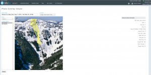
|To access the content of an Infoex report template, click on the REPORTS menu and pick the report template you want to look at (Fig. 1). | |To access the content of an Infoex report template, click on the REPORTS menu and pick the report template you want to look at (Fig. 1). | ||
| − | |rowspan=2|[[File: | + | |rowspan=2|[[File:Photo_Overlay_Viewer.PNG|300px|thumb|right|Fig. 1: Photo Overlay Viewer.]] |
|- | |- | ||
|class="StepNum" | 2. | |class="StepNum" | 2. | ||
Revision as of 12:56, 30 May 2017
| REQUIREMENTS | |
| Permission | All user levels |
| Connectivity | Online only |
This document describes how to view photo overlays submitted with avalanche observations, avalanche control observations or snowpack observations.
Step-by-step description
| 1. | To access the content of an Infoex report template, click on the REPORTS menu and pick the report template you want to look at (Fig. 1). | |
| 2. | Wait for the application to retrieve and display all of the information for the report you chosen. |
Related documents
Customizing reports
[1] Click to watch a help video
[2] Click to watch a help video
- Content
- Specifying the date or date range of an InfoEx report
- Restricting the locations included in an InfoEx report
- Specifying the tables to be included in an InfoEx report
- Adding or removing columns of individual tables in an InfoEx report
- Applying filters to individual tables in an InfoEx report
- Including or excluding proprietary information in an InfoEx report
- Layout
Managing report templates
- Saving a report as an InfoEx report template
- Modifying an existing InfoEx report template
- Deleting an existing InfoEx report template
- Signing up for the daily InfoEx report emails
Viewing report templates
Map Layers
- Operation overview
- Avalanche observations
- Avalanche hazard
- Snow Profiles
- Field summary
- Weather observations
- Time slider (used for all map layers)
- Additional external information sources
Charts
Functionality tested by
- Jan 1, 2014: Pascal Haegeli
